-
A complete GIS analysis package for basic and advanced spatial analysis, including tools for surface and statistical analysis, decision support, and change and time series analysis
- A complete Image Processing system with the most extensive hard and soft classifers in the industry, including machine learning classifiers such as neural networks and classification tree analysis, as well as image segmentation for classification
- Integrated modeling environments including the Earth Trends Modeler for image time series of environmental trends and Land Change Modeler for land change analysis and prediction, a critical component for REDD projects
- Complete utilities for import and export along with a comprehensive set of documentation and tutorials.
Learn more about IDRISI Selva
IDRISI Selva Brochure (PDF)
IDRISI Selva Technical Specifications (PDF)
What's New in IDRISI Selva (PDF)
With IDRISI Selva, you can:
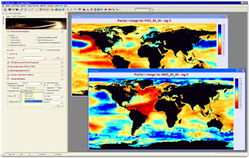
Analyze trends and anomalies of image time series with the innovative Earth Trends Modeler facility.

The Earth Trends Modeler is a vertical application included with IDRISI Selva and specially designed for the analysis of image time series. It includes a coordinated suite of data mining tools for the extraction of trends and the underlying determinants of variability.

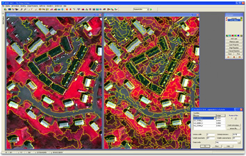
The SEGMENTATION module creates an image of segments that have spectral similarity across many input bands. The image on the left uses a larger similarity threshold than the one on the right, resulting in more generalized, less homogeneous segments. Using this threshold, the image allows for segments that wholly contain building objects.
For more info please visit http://www.clarklabs.org/products/idrisi.cfm
|

