|
|
JAVAD JUSTIN SOFTWARE |
| |
Justin has full range of features for geodetic and surveying tasks.
-
We offer Justin software in two versions - Justin Lite and Justin.
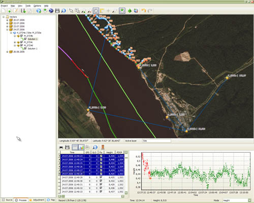
Justin Lite: GPS&GLONASS baseline, trajectory processing, Scenario, Adjustment, Observation manager, Coordinates calculator, Event Editor, Global Geoid, Mission Planning, Export to RINEX, Points manager, Vertical profile, Cartographic window, Data Visualization, Antennas, Report
Justin: Import GNSS data, Virtual Station, Datum calculator, Enhanced Geoid Model, Vector maps, Raster manager, Map printing , Export map, Data Analyser, Google visualization, Data Interpolation.
| Module |
Justin
Lite |
Justin |
Comments |
| Importing raw data |
 |
|
JUSTIN-authorized *.jps |
| Import GNSS data |
- |
|
all *.jps, RINEX, sp3, DTM, snap-, o-files |
| Scenario |
|
|
Project manager: automatic data processing from import, snapping data to points, baseline calculation, adjustment to report |
| Baseline, trajectory processing |
|
|
Static, kinematic, stop&go GPS&GLONASS data |
| Adjustment |
|
|
Geodetic networks adjustment. Processing very large-scale networks of up to 3000 stations |
| Trajectory adjustment |
|
|
Adjusting kinematic data with multiple bases |
| Virtual Station |
- |
|
High (up to 100Hz) rover and low base rate (CORS) vector processing |
| Observation manager |
|
|
Merging, splitting, picking, interpolation data |
| Coordinates calculator |
|
|
Cartographic projections, ellipsoids, datum |
| Datum calculator |
- |
|
Local datum calculation |
| Event Editor |
|
|
Event positioning |
| Global Geoid |
|
|
EGM96 |
| Enhanced Geoid Model |
- |
|
Export/Import Geoid and Height Calculator |
| Mission Planning |
|
|
Almanac data viewer |
| Export to RINEX |
|
|
RINEX 2.11 |
| Points manager |
|
|
Export/Import reference point coordinates |
| Vertical profile |
|
|
Manage data using vertical profile |
| Cartographic window |
|
|
Zooming, Panning, Ruler, Layers, Labeling |
| Vector maps |
- |
|
Open ESRI shape and MapInfo tab |
| Data Visualization |
|
|
Orbits, SV common view, standard data combinations, GDOP |
| Raster manager |
- |
|
Raster transformation and georeferencing |
| Map printing |
- |
|
Printing map in different scales |
| Export map |
- |
|
Export to dxf, tab formats |
| Data Analyser |
- |
|
Scientific application ( GNSS data analysis charts ) |
| Antennas |
|
|
NGS Antennas Data Base |
| Report |
|
|
Navigation, processed, adjusted data, events |
| Google visualization |
- |
|
View project network in Google Earth |
| Multilingual support |
|
|
English, Russian, Turkish |
| |
|
|
| |
|
| |
We will continue to enhance Justin to process Galileo and other new signals as they become available
Justin Read This First
|
|
| |
|
|